By tonight there should be a pretty big ramp up in coverage of Hurricane Irene. Irene is a Category 1 Hurricane located north of the Dominican Republic. It appears less and less likely that the circulation is going to be disrupted by the mountains of the DR. It appears more and more likely that Irene will become a major Hurricane (Sustained winds greater than 111 mph). Already 800,000 people are out of power on Puerto Rico and over 10 inches of rain has fallen. Next in line after the DR are the Turks and Caicos Islands and the Southern Bahama's. Most models are taking the threat away from Florida and sending Irene to the Carolina's. However, one very reliable Hurricane model is refusing to take the storm up the coast; instead this model is sending Irene to Miami as a category 4 hurricane. I don't buy the solution, but its hard to ignore and discount the model since it has been consistent. It remains an uncertainty and I want to let it be known that not all models favor a Carolina track; however I believe North Carolina and then New England are in a greater danger area.
 |
| IR satellite imagery of Irene, courtesy NHC |
Whenever there is record, prolonged heat in Texas Hurricanes tend to travel up the east coast. New England is a favorite target, as was the case in 1954 and 1999. Hurricanes Carol and Edna both struck Southern New England within 3 weeks of one another. In 1999 Hurricanes Dennis and Floyd both struck North Carolina, with Floyd continuing up the East Coast and crossing New England as a tropical storm. Both the GFS and the EURO long/medium range models are latching on to this solution. It is still 6 days away; the track could change. However, weather patterns repeat themselves and so far 2011 has been an extreme year. It has been reminiscent of the 1950's. So here is my forecast track and cone of uncertainty
 |
| My forecast for Irene |
The National Hurricane Center has already nudged its track east from yesterday
 |
| National Hurricane Center forecast and watches/warnings |
So while it is too early to panic over Irene, here is what
potentially could happen. First of all, New England hasn't been struck by a major Hurricane since the aforementioned Carol of 54. That hardly matters because the damage from Hurricane Bob (91) was extensive and that made landfall as a Category 2 (which is what I am forecasting now). Let's start with the Cape, Islands and South coast. Storm Surge will be on the magnitude of 10-15 ft, severely damaging low lying areas along Buzzards and Narragansett Bays. Boats will be sunk or tossed ashore from 20-30 ft waves on top of the surge. Heavy wind damage and power outages will also knock out communications from the storm. There has been a lot of rain already this year and so the ground is saturated; that means it will be easier for the strong winds to knock down trees and take down power lines. Further inland, flooding rains and high winds will knock out power and take down trees. Rivers will rise and low lying areas will see river flooding. The outer bands of Irene will drop tornadoes causing more damage. All of this is based off accounts of previous Hurricanes that have hit New England. This will happen IF we take a direct hit.
Why do I warn of this at such an early stage? New England is ill prepared for a Hurricane. Coastal development has boomed since Bob and this storm could be stronger than Bob. If you know people who live down the Cape or along the coast now is the time to think about what to do if officials order evacuations. Now is the time to make sure you have enough food and water for up to 3 days (per person). Now is the time to collect important documents and keep them handy. If the storm bends out to sea consider this a practice Hurricane Drill. If it does hit you beat the rush to the stores on Thursday, Friday, and Saturday.
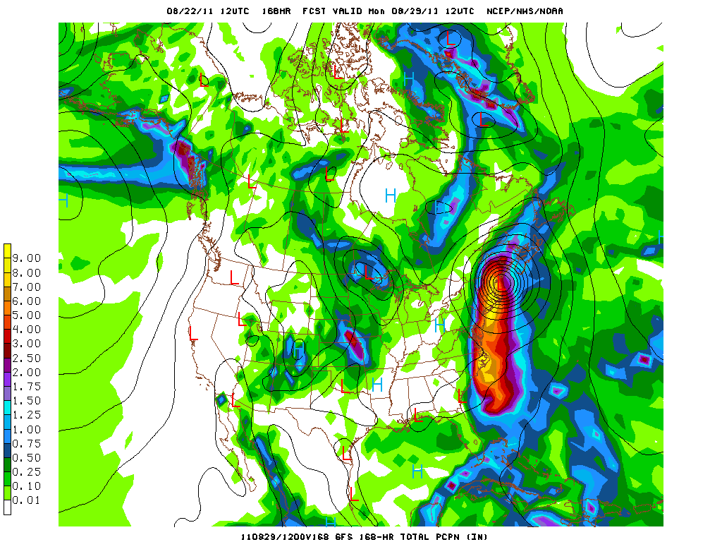
Here is the amount of predicted rainfall for from hour 108 (4 and half days) to hour 168 (7 days out)
 |
| NCEP GFS 60 hr precip hour 168 |
Its been 20 years since a direct Hurricane hit. The luck may be running out. One last image for everyone...
 |
| 500 mb vorticity map, GFS 12 utc run, Monday morning 2 am |
There is nothing definite yet, but a Hurricane is something no one around here is use to dealing with. A NOAA research plane is schedule to investigate the environment out ahead of Irene today. If the models continue to track Irene north after this, the threat level will be increased.


No comments:
Post a Comment