Friday, April 29, 2016

Daily Weather Briefing Friday April 29, 2016

(Editors note- I will slowly be adding content to these daily weather briefings until it is a well oiled machine.  Any feedback is appreciated.  I will start with a national outlook and then issue our Southern New England forecast after that before going into some other things)

Yesterday's Recap
We have to go back to Tuesday first.  After strong criticism from some corners of the meteorology world  about lots of hype but not a lot of tornadoes the National Weather Service has finished its storm surveys. They have found that 20 tornadoes formed during the event.  Now they weren't the devastating long track tornadoes like the April 27, 2011 event so in some peoples minds it is a bust.  But is it?  I don't think so. Thursday featured some severe weather in North Carolina and the Texas panhandle (among other places)
SPC 9 AM severe weather outlook for Thursday with actual storm reports
Notice the red dot in Indiana.  That is the days lone tornado report and it shows up just in a regular thunderstorm risk.  That goes to show that no matter the forecast risk one must be vigilant for severe weather anytime there is a chance of thunder.

National Outlook
Let's start with the temperatures.  Seasonable temperatures in New England, summer like in the south and cold in the Rockies under the upper trough.
NWS High temp forecasts Friday (image Weatherbell)

Here is the upper air pattern for 2 PM.  I've circled the 3 main players for national weather today
12z NAM 500 mb vort valid 2 PM EST (Image NCEP)
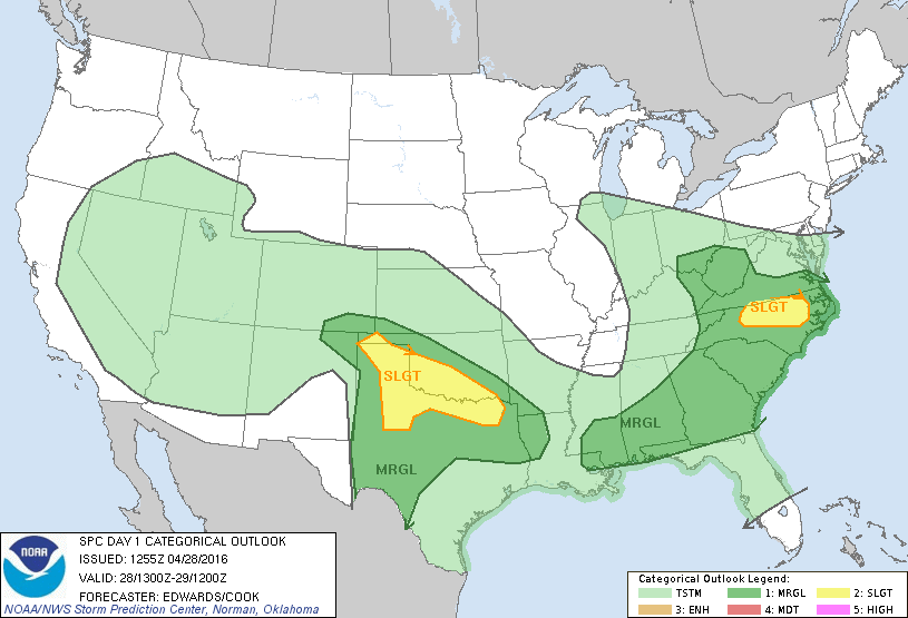
The circle in the Great Lakes represents a shortwave that will bring showers to the Mid Atlantic tonight.  The circle in Northern Mexico will help feed a surface low pressure system in South Central Texas that will eventually contribute to a line of thunderstorms in Eastern Texas later today.  The third circle is part of system that will drop snow in the Rockies and severe thunderstorms in the Red River Valley.  Here is the severe threat
SPC Day 1 severe weather outlook through Saturday 8 am
There is a 10% tornado chance just like Tuesday (but without the hype)
SPC Day 1 tornado outlook
As low pressure move east across Texas and a warm front lifts north the Red River area looks prime for tornadoes if the upper atmosphere can destabilize.  Here is the simulated radar for 8 PM tonight coast to coast
13z HRRR National simulated radar 8 PM (image Weatherbell)
 Major threats are flash flooding, large hail, wind damage and isolated tornadoes.  It looks pretty nasty in Oklahoma City this evening.  Now most of the snow will fall at higher elevations.  Denver will go from snow to rain back to snow.  In general 4-8" fall in the Rockies
13z HRRR total snowfall through midnight (Image Weatherbell)
Some MLB games to keep an eye on- Giants at Mets, Angels at Rangers and Nationals at Cardinals.  I think the rain will make for a terrible night at Citi Field and may lead to a cancellation.  In Texas the cold front should pass Arlington before the game starts but it could be really nasty for fans arriving early for BP and tailgating.  Early rain will end before the Nats-Cards but another round of rain will move into the area by the middle innings.

Southern New England Forecast
Partly sunny skies today give way to showers in Western MA and CT this evening.  After this passes we clear. High temps are near 60 before dropping to 40 overnight.  Here is the 9 PM radar
14z HRRR simulated radar 9 PM (image Weatherbell)
This is associated with the circle in the Great Lakes in the upper air image above.  It clears for Saturday.  Saturday is the pick of the weekend with temperatures in the mid 60s and mostly sunny skies (50s near the coast).

Where I'd Like To Be Today
Myrtle Beach, SC.  Sunny skies, a slight North wind with temperatures around 80.   Water temperatures are running around 60-62 F but that's no problem for a Northern Boy.

On This Date
A borderline Category 4/5 cyclone made landfall in Bangladesh killing upwards of 200,000 people and causing over a $1 billion in damage.  Bangladesh is extremely vulnerable to cyclones because of the shape of its coastline and the ocean floor leading to its coastline.  The slope is gradual rather than steep so storm surge can really grow.
Track of 1991 Cyclone
With a concave coastline shape when the water is funneled toward the coast it has nowhere to go but to pile up onshore. A 20'+ surge flooded the lowlands and killed numerous people who ignored the forecast or did not know about the storm.

-Zack Green

Thursday, April 28, 2016

Daily Weather Briefing Thursday April 28, 2016

After all the hype Tuesday received for its tornado potential Wednesday actually exceeded Tuesday's tornado count!  The total number of severe reports and damage was much greater on Tuesday which goes to show its not just about tornadoes.  The SPC did pretty well yesterday.  I said watch out for Southern Illinois but it turns out the tornado activity was fairly widespread.
SPC severe reports for 4/27 over outlook issued 2 AM 4/27
Today the storm threat has shifted further south
SPC Day 1 Outlook
The main areas of severe weather are along the stationary boundaries in Texas and along the warm front in North Carolina.  Seasonable conditions are in place in the Upper Midwest and Northeast.  Rain will move northward into the Great Lakes, PA, NY and parts of Southern New England later today.
US Surface Analysis 8 am (WPC)
Low pressure will slide well south of New England as high pressure is in control.  I can't see much rain unless its in Southern CT/RI and even then amounts will be very light. The reason is flow is pretty zonal so instead of storms lifting into New England they will continue east without heading north
12z NAM 500 mb vort 5 PM EST
Temperatures will warm into the 60s away from the coast in Southern New England while its summer like in the south, fall like in the Midwest.  A lot of the cool air in NJ, PA, WI and MN has to do with rainfall keeping temperatures cool.
14z HRRR 2 m temps 5 PM EST (image weatherbell)
High resolution radar suggests the Texas panhandle as the place to watch for super cells this afternoon.  At 8 PM EST the national radar will look something similar to this
14z HRRR simulated radar 8 PM (image weatherbell)
The thunderstorms in North Carolina will be fairly intense as well in association with a surface low pressure system.  The west remains unsettled underneath the big trough.  Temperatures are below normal out there and this will only slowly progress east into the plains over the next few days.  

Southern New England
Some sprinkles and increasing clouds along the south coast gives way to low temps around 40.  The cloud cover keeps it from going as cold as it could go.  Tomorrow highs generally 58-62 except at the coast where it will be around 50.  Partly sunny skies tomorrow.

On This Date
A record setting snowstorm buried parts of Kentucky, North Carolina, Maryland, West Virginia and Pennsylvania in 1928.  A low formed in the Gulf of Mexico and lifted northeast towards the Carolina's.  A new secondary low began to form as cold air surged south through the Ohio Valley.  Moist Atlantic and Gulf air met this cold air mass and snow churned out on the 27 and into the 28th.  Telegraph and power lines were knocked out as well as many trees and powerlines.  Snowfall totals topped 40" in WV, 36" in PA,  15.5" in KY, 14" in VA, 13" in NC.  All of these snow totals were at elevations of 1000-3000'.  
Information taken from June 1928 Monthly Weather Review

Coming later- a summary of 2016 Atlantic Hurricane Seasonal forecasts already released.

-Zack Green 

Wednesday, April 27, 2016

5 Years Later- April 27, 2011 Severe Weather Outbreak

(For Wednesday forecast/Tuesday recap see here)
The forecast for severe weather and tornadoes in the Plains yesterday brought back terrible memories for millions of people in the Southeast yesterday as we are at the 5 year anniversary of one of the worst severe weather outbreaks in US history.  2011 featured stunning extreme weather from January through October before warm Pacific flow finally calmed things down.  This outbreak plus Joplin, Hurricane Irene and the Halloween Blizzard all made 2011 one of infamy for many.
4/27/2011 storm reports (note- the 292 tornadoes was revised to 199)
Meteorological Conditions
The severe weather outbreak began a few days earlier as tornadoes were spawned in Texas, Louisiana, Arkansas, Mississippi, Tennessee, Kentucky and some other states as early as April 24.  A series of upper level disturbances dropped a trough deep into the south.  Here is the 500 mb pattern at 7 AM on April 27
500 mb obs, winds, heights, temps 8 AM 4/27/11 (image NOAA)
Notice strong winds along the base of the trough.  Here is a composite of the 500 mb winds, 850 winds, dewpoints
The strong winds at 850 mb (red) would help turn the surface southerly flow ensuring low level rotation.  The strong 500 mb winds would help ensure long track tornadoes.  The warm moist atmosphere would ensure plenty of fuel for super cell thunderstorms.  This is a textbook set up. As the sun destabilized the atmosphere further  super cells did indeed form.  Here is a radar loop across Alabama
Birmingham radar loop 4/27/11
The severe threat continued.  At 7 PM the composite atmosphere looked like this
The result was catastrophic and ruinous.  
Impact
Here are the Southeast tornado tracks
NOAA tornado track survey April 25-28
In all 219 tornadoes formed on April 27. For the total outbreak 363 tornadoes formed from Texas to New York.  The total death toll from the event is 324 with over 2200 injuries.  For just April 27

It was an astonishing south of force from mother nature.  Here are some images of the damage.
Tuscaloosa tornado 4/27/11 (image severe studios) 
Tuscaloosa from above after tornado 
Concord, AL damage (image Atlantic)
It was also in 2011 that a strong EF-3 tornado ripped through Springfield, MA.  We are not immune from tornadoes in Southern New England.  In fact on the same day as the famous Worcester tornado of 1953 (killed 94 people) a tornado ripped through my hometown of Northbridge, MA.  Keep up with the blog and you'll be prepared.

-Zack Green

Wednesday US Weather Briefing

I'm not sure how much hype the projected tornado outbreak received as I was sitting in the sun (sometimes the casino) in Las Vegas.  After seeing some of the reactions on twitter it seems the event under preformed.  Perhaps these were storm chasers who need these storms for income but in my opinion when there are less tornadoes than forecast that is a good thing.  I'm not sure we can call this a bust.  There was a 10% chance of tornadoes in the plains within 25 miles of a given point.  That's not huge odds.  Here are the storm reports over the 9 AM outlook.
SPC Day1 outlook 4/26/16 9AM with severe reports for 4/26/16
I don't think this is the SPC's best forecast but its not bad.  The threat in the Mid Atlantic never materialized nor the tornado threat.  But lets not act like there wasn't a lot of damage from winds and the tornadoes that did drop from the sky.  For example in Grayson County, TX
Tornado damage via CBS Dallas 
Why were there less tornadoes than anticipated?  The wind shear was not great enough nor was the upper low as strong as it should it have been.  The 500 mb pattern didn't have the classic negative tilt needed for super outbreaks so winds just did not rotate as they climbed the atmosphere as well as they could have.

Today's Threat
This system has progressed east with more severe weather forecast in the Lower Mississippi Valley and the Southeast.
SPC Day 1 severe weather outlook
Watch out for Southern Illinois for a sneaky tornado threat today.  The tilt of the upper trough is much greater and the HRRR is showing some supercell potential around 6-7 PM CDT
16z HRRR simulated radar valid 8 PM EST (image Weatherbell)
Elsewhere in the US high pressure is taking control over the northern tier
WPC 11 am surface analysis 
Given this surface chart the US temperatures come as no surprise.  Warm in the Southeast and chilly for late April elsewhere although it is a significant improvement in New England and the Upper Midwest
US 2 m temps 1 PM (image Weatherbell)
Waves of low pressure will continue to move along the cold front today.  Look how well the precipitation forecast lines up with the gradient of warm/cold.  This is a 2 day forecast so Texas and the southeast get their rain as the front finally moves east.
WPC Day 1-2 precipitation forecast 
On This Date
Today is the 5 year anniversary of the 2011 Super Tornado Outbreak that killed over 300 people, many in Alabama.  This deserves it own post.  


Tuesday, April 26, 2016

Severe Weather to Impact Millions Today

A pair of upper level disturbances will led to severe weather in multiple parts of the US today.  The most significant threat is for tornadoes in the Great Plains as an upper atmosphere low lifts out of the Rockies.  In the Northeast a warm front has lifted just south of New England which has led to periods of rain in Southern New England, snow in Northern New England.  As result of such cold air aloft the biggest threat in Philadelphia and surrounding areas is hail.  Here is the Storm Prediction Center threat graphic
SPC Day 1 thunderstorm outlook (valid through Tuesday 8 am EST)
Here is the surface analysis as of 8 AM EST
WPC surface analysis 8 AM EST
That stationary boundary is a clear divided of where the warm and cold air is in the lower 48.  Anyone in New England right now knows what I mean.
US 2 m temps 10 AM EST (image Weatherbell)
So by 2 PM the warm front will halt its progress north.  A wave of low pressure will slide south of New England leading to heavy rain until about 2 PM.  The good news for New England is that high pressure will take over and led to seasonable weather through the weekend.  All storm will slide south out to sea while temperatures remain around 60.  As the afternoon goes in in the Plains more thunderstorms will erupt.
WPC surface forecast 2 PM
Here is the simulated radar for 6 PM EST/5 PM CST.  It looks like some super cells will begin to erupt by this time in Oklahoma and Kansas.  A strong complex of wind, hail, lightning and rain will move along the cold front through Missouri, Illinois, Indiana, Kentucky at the same time.
14z HRRR simulated radar 6 PM EST (image weatherbell)
This lines up well with the SPC tornado threat area
SPC Day 1 tornado outlook
I'm not sold on Nebraska as it may not get warm enough but it will be close.  Central Kansas and West of Oklahoma City are my best bets to chase today.  This whole area moves east for tomorrow but the tornado threat will be less than it is today.  I'll let this play out and summarize the event tomorrow.

-Zack Green

Tuesday, April 19, 2016

Bill Nye Issues 20K Challenge to Joe Bastardi

Anyone born between 1980-1995 grew up watching Bill Nye the Science Guy either for fun (guilty) or in science class.  Bill had a way of taking something complicated and breaking into simple terms for simple minds to understand.  Recently Bill has been one of main faces of the global warming/climate change.  This is somewhat odd because Bill has a BS in Mechanical Engineering but its a smart play by the liberals.  They know young people know who he is and they know we will listen to his message.

Joe Bastardi on the other hand is the co-chief meteorologist at Weatherbell Analytics.  He has a BS in meteorology from Penn State and spent a long time at AccuWeather.  Joe is known for some excellent long range forecasts and for being a climate skeptic or denier.  I have subscribed to Weatherbell since it opened because Joe and his team look at the weather in a very unique way and I have learned a lot.  Joe is a darling of Fox News and the conservative movement against climate change legislation/action.  Its also been said you can't spell Bastardi without and I and that criticism is valid.  JB has a HUGE EGO. Sometimes Joe thinks he is the only one who can spot a weather pattern 1-2 weeks away and it rubs a lot of people the wrong way.  He probably doesn't get the credit he deserves for some of his forecasts because he is a loud mouth like Joey Porter or Terrell Suggs.

Now 6 years ago Joe and Bill went on O'Reilly and butted heads.  This is a 6 minute video
Bastardi's point on Venus is pretty stupid but overall I score that a victory for JB.  Well that was 6 years ago and Bastardi has been predicting a "triple crown of cooling".  Instead we've had the warmest ocean and some of the warmest years on record.  I admit when I was in college/just out I thought the whole global warming thing was a scam but that was because the other side was calling every single weather event unprecedented and because of global warming.  That was bullshit then and that is bullshit now.  But after gaining experience in the environmental field I've moved to the center on this.  I'm pro renewable energy and I'd like it sooner rather than later.  I want to push for aggressive environmental controls to combat urban flooding, storm surge and other natural disasters.  

Anyway in November JB published this article on the Patriot Post . Read the article.  Now here is Bill Nye's response
Here is what stands out to me.  

1) Bill Nye will be correct on his forecasts

2) Bill Nye blew up Joe's carbon dioxide graph.  Life and land were much different in the past and certainly contributed to the CO2 divergence. 

3) Bill doesn't mention anything about JB's claim that the earth will cool AFTER 2016 and the 20 year period from the late 1990's to late 2010's will be nearly flat on the temperature scale.  

4) JB does futures/commodities forecasting for gas/oil companies and yes has spoke at conferences for them

What does it mean?  I'm not really sure.  I'm actually sick of it to be honest.  Its probably time to kick some people out of the conversation who only bring negativity.  Its time to acknowledge its not just natural changes that are influencing the climate and environment.  Its also time for some to acknowledge that natural climate cycles exist and that they also need to be studied.  There is so much going on in the world and we are already so divided.  The weather doesn't need to be something that divides us.  Let's put some differences aside, admit we are wrong (it feels good) and start solving problems.

Monday, April 18, 2016

Fire Weather Watch Tuesday

Day 2 Fire Weather Outlook SPC
Dry conditions and gusty winds will lead to an elevated risk of fine fuel fires this evening ad Tuesday.  As a result the National Weather Service in Taunton has issued a Fire Weather Watch.  Although a low will pass through Northern New England tonight bringing accumulating rainfall that will miss the southern portion of the region.  Humidity levels will drop as low as 25%.  It won't even be that warm tomorrow as max temps are near 60.  But some gusty winds and the low moisture content in the atmosphere pose a dangerous combo.
NWS Boston Headlines/Hazards
Although we have seen some rains lately there are still areas of PA, NY, CT, MA and NH that have abnormally dry drought conditions.  We have made big strides since September however (image 2)
US Drought Monitor 4-12-16
September
US Drought Monitor 9-29-2015
Fire officials recommend avoiding outdoor burning at all costs.  If you must burn apply for a permit.  You shouldn't do this anyway but don't just chuck your cigarette out the window.  Make sure its out in an ashtray or a cigarette bucket.  Yes I know "you shouldn't smoke anyway" but that fact is people do so lets avoid a forest fire.

By the way- opposite problem in Texas.  See my post from earlier here

Heavy Rains Flood Southeastern Texas

In general the weather is nice throughout the lower 48 on this Monday April 18.  The major exception is in Southeastern Texas where a slow moving system has dropped nearly 10" of rain in places.  Radar estimates of rainfall are over a foot in places west of Houston
NWS Houston/Galveston radar estimates Saturday PM-now
This is what that much rain in a short amount of time will do
Photo via Reed Timmer/twitter 
On the ground
Via ABC 7/twitter
Off an overpass
Via CNN/Twitter
Unfortunately there are starting to be reports of fatalities.  Floods are the number one killer of Americans in a given year.  So what exactly is causing this?  At the surface a stationary boundary is situated across Central Texas with a upper low to the west in the Rockies and high pressure in the Eastern US
WPC Surface analysis 2 PM EST
The counter clockwise flow around the low and the clockwise flow around the high are allowing for convergence in Southeast Texas.  This is better shown at the mid levels of the atmosphere
12z NAM 500 mb vort 8 am
The upper low in the Atlantic is not moving and neither is the high in the Southeast.  As result of the upper low in the Rockies which dropped 4 feet of snow this weekend we have an "omega" block because the atmospheric pattern looks like the Greek letter Omega.  On Tuesday-Wednesday the jet stream will break this block temporarily (looks like the pattern returns by the end of the week but further east).  It will be slow to get out of Texas but the heaviest rain will shift north of Houston and east of Dallas into Arkansas and Louisiana.
WPC 1-3 day rainfall (begins 8 PM tonight ends 8 PM Thursday)
As Dr. Marshall Shepherd (U of Georgia, Florida State) described on twitter part of the problem with these heavy rain events is the amount of blacktop pavement that this water is able to just run down.  Combine it with outdated storm drain designs and some added warmth to the atmosphere and we have flash flooding problems.  On the other hand global warming isn't responsible for the omega block.  The same people who claim that also claimed our warm March was global warming.  Well in March there was very little blocking and a fast jet across the US.  As usual the truth is in the middle but very few people sit in the middle anymore.

Good luck to everyone suffering in Texas today.


National Weather Service Issues Winter Storm Warning

T he National Weather Service Boston office has issued a * Winter Storm Warning * for most of Southern New England, except for the South Sou...