 |
| SPC severe reports for 4/27 over outlook issued 2 AM 4/27 |
Today the storm threat has shifted further south
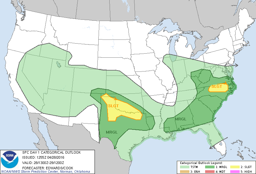 |
| SPC Day 1 Outlook |
The main areas of severe weather are along the stationary boundaries in Texas and along the warm front in North Carolina. Seasonable conditions are in place in the Upper Midwest and Northeast. Rain will move northward into the Great Lakes, PA, NY and parts of Southern New England later today.
 |
| US Surface Analysis 8 am (WPC) |
Low pressure will slide well south of New England as high pressure is in control. I can't see much rain unless its in Southern CT/RI and even then amounts will be very light. The reason is flow is pretty zonal so instead of storms lifting into New England they will continue east without heading north
 |
| 12z NAM 500 mb vort 5 PM EST |
Temperatures will warm into the 60s away from the coast in Southern New England while its summer like in the south, fall like in the Midwest. A lot of the cool air in NJ, PA, WI and MN has to do with rainfall keeping temperatures cool.
 |
| 14z HRRR 2 m temps 5 PM EST (image weatherbell) |
High resolution radar suggests the Texas panhandle as the place to watch for super cells this afternoon. At 8 PM EST the national radar will look something similar to this
 |
| 14z HRRR simulated radar 8 PM (image weatherbell) |
The thunderstorms in North Carolina will be fairly intense as well in association with a surface low pressure system. The west remains unsettled underneath the big trough. Temperatures are below normal out there and this will only slowly progress east into the plains over the next few days.
Southern New England
Some sprinkles and increasing clouds along the south coast gives way to low temps around 40. The cloud cover keeps it from going as cold as it could go. Tomorrow highs generally 58-62 except at the coast where it will be around 50. Partly sunny skies tomorrow.
On This Date
A record setting snowstorm buried parts of Kentucky, North Carolina, Maryland, West Virginia and Pennsylvania in 1928. A low formed in the Gulf of Mexico and lifted northeast towards the Carolina's. A new secondary low began to form as cold air surged south through the Ohio Valley. Moist Atlantic and Gulf air met this cold air mass and snow churned out on the 27 and into the 28th. Telegraph and power lines were knocked out as well as many trees and powerlines. Snowfall totals topped 40" in WV, 36" in PA, 15.5" in KY, 14" in VA, 13" in NC. All of these snow totals were at elevations of 1000-3000'.
Information taken from June 1928 Monthly Weather Review
Coming later- a summary of 2016 Atlantic Hurricane Seasonal forecasts already released.
-Zack Green


No comments:
Post a Comment