Monday, August 22, 2011

Hurricane Irene- The Latest

By tonight there should be a pretty big ramp up in coverage of Hurricane Irene.  Irene is a Category 1 Hurricane located north of the Dominican Republic.  It appears less and less likely that the circulation is going to be disrupted by the mountains of the DR.  It appears more and more likely that Irene will become a major Hurricane (Sustained winds greater than 111 mph).  Already 800,000 people are out of power on Puerto Rico and over 10 inches of rain has fallen.  Next in line after the DR are the Turks and Caicos Islands and the Southern Bahama's.  Most models are taking the threat away from Florida and sending Irene to the Carolina's.  However, one very reliable Hurricane model is refusing to take the storm up the coast; instead this model is sending Irene to Miami as a category 4 hurricane.  I don't buy the solution, but its hard to ignore and discount the model since it has been consistent.  It remains an uncertainty and I want to let it be known that not all models favor a Carolina track; however I believe North Carolina and then New England are in a greater danger area.
IR satellite imagery of Irene, courtesy NHC
Whenever there is record, prolonged heat in Texas Hurricanes tend to travel up the east coast.  New England is a favorite target, as was the case in 1954 and 1999.  Hurricanes Carol and Edna both struck Southern New England within 3 weeks of one another.  In 1999 Hurricanes Dennis and Floyd both struck North Carolina, with Floyd continuing up the East Coast and crossing New England as a tropical storm.  Both the GFS and the EURO long/medium range models are latching on to this solution.  It is still 6 days away; the track could change.  However, weather patterns repeat themselves and so far 2011 has been an extreme year.  It has been reminiscent of the 1950's.  So here is my forecast track and cone of uncertainty
My forecast for Irene
The National Hurricane Center has already nudged its track east from yesterday
National Hurricane Center forecast and watches/warnings
So while it is too early to panic over Irene, here is what potentially could happen.  First of all, New England hasn't been struck by a major Hurricane since the aforementioned Carol of 54.  That hardly matters because the damage from Hurricane Bob (91) was extensive and that made landfall as a Category 2 (which is what I am forecasting now).  Let's start with the Cape, Islands and South coast.  Storm Surge will be on the magnitude of 10-15 ft, severely damaging low lying areas along Buzzards and Narragansett Bays.  Boats will be sunk or tossed ashore from 20-30 ft waves on top of the surge.  Heavy wind damage and power outages will also knock out communications from the storm.  There has been a lot of rain already this year and so the ground is saturated; that means it will be easier for the strong winds to knock down trees and take down power lines.  Further inland, flooding rains and high winds will knock out power and take down trees.  Rivers will rise and low lying areas will see river flooding.  The outer bands of Irene will drop tornadoes causing more damage.  All of this is based off accounts of previous Hurricanes that have hit New England.  This will happen IF we take a direct hit.  

Why do I warn of this at such an early stage?  New England is ill prepared for a Hurricane.  Coastal development has boomed since Bob and this storm could be stronger than Bob.  If you know people who live down the Cape or along the coast now is the time to think about what to do if officials order evacuations.  Now is the time to make sure you have enough food and water for up to 3 days (per person).  Now is the time to collect important documents and keep them handy.  If the storm bends out to sea consider this a practice Hurricane Drill.  If it does hit you beat the rush to the stores on Thursday, Friday, and Saturday.  

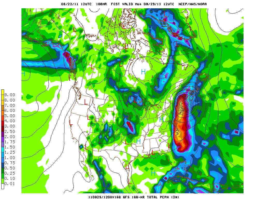
Here is the amount of predicted rainfall for from hour 108 (4 and half days) to hour 168 (7 days out)
NCEP GFS 60 hr precip hour 168
Its been 20 years since a direct Hurricane hit.  The luck may be running out.  One last image for everyone...
500 mb vorticity map, GFS 12 utc run, Monday morning 2 am
There is nothing definite yet, but a Hurricane is something no one around here is use to dealing with.  A NOAA research plane is schedule to investigate the environment out ahead of Irene today.  If the models continue to track Irene north after this, the threat level will be increased.


Sunday, August 21, 2011

Irene Update

Tropical Storm Irene is nearing Hurricane strength as she bears down on Puerto Rico.  Here is the latest Infrared  Rainbow Satellite Image.
Tropical Storm Irene- winds at 70 mph
Winds are up to 70 MPH and pressure has dropped to 989 mb.  This already makes Irene as the strongest storm of this season thus far.  Irene will break this shortly.  Puerto Rico is certainly in for a rough night.   Winds will gust to 80 mph and flash flooding is likely as 5-10 inches of rain will fall on the island.  I had hoped to get a radar image of the Hurricane on the blog, but the images are currently down.  This confirms how strong Irene has already gotten.  With pressure down to 989 I expect Irene to be a Hurricane by 2 AM.
My track forecast for Irene

National Hurricane Center forecast 
I believe the National Hurricane Center is keeping the track too far to the west.  They note in their 11 pm discussion that they are uncertain of what effects the mountainous terrain of Hispaniola will have on the system.  I believe the storm is hardly effected by these and will strengthen, turning north more quickly.  Also, Jacksonville, FL is hardly ever hit by tropical systems.  Hurricane Cleo (1964) hugged the Florida coast and is noted by some forecasters as a possible parallel.  However Hurricane Dora (also 1964) is the only Hurricane since 1851 to directly hit Jacksonville.  So I am doubting the NHC forecast.  Model consensus has pushed further east, over the gulf stream.  This is a potential alarming trend, due to how warm the waters of the Gulf Stream are.  Its not just how warm the GS is either- a Hurricane will intensify when it moves over pools of warm water due to fluctuations in how quickly new thunderstorms are forced upward in the core (lapse rates).   For example, water that is 82 degrees over a large area will keep a Hurricane going with moderate strengthening if all other conditions are equal.  But if there is a patch of 83 or 84 degree water in its path, the storm is more likely to rapidly intensify. 

I've gone stronger than the Hurricane Center on intensity, but not as aggressive as some of the weather models.  The timing is questionable.  I will refine that tomorrow after reviewing tonight and the morning model runs.  At this point, I think New England will see some sort of enhanced rainfall from this system next weekend.  While looking at my 6 day track you can probably guess where I'm leaning with it, I'm not ready to sound any sort of hype alarm until the storm starts to make its turn north.  Warm Atlantic Ocean, second year of a La Nina is a classic East coast Hurricane signature, specifically North Carolina.  Out of all the areas this is where I am most concerned for.  The latest American long range model is out its "initial condition" already is too far south for where the storm currently is.  Get your popcorn ready weather fans!


Severe Thunderstorm Watch 795

A severe thunderstorm watch has been issued for Western and Central Massachusetts.  The watch is in effect until 900 PM tonight.  Damaging wind and large hail are the main threats from this complex of thunderstorms.  A vigorous line of thunderstorms is approaching the Berkshires now.  Check out spc.noaa.gov for more information.

Saturday, August 20, 2011

Sunday Thunderstorms and Tropical Storm Irene

Hope everyone enjoyed the first part of the weekend.  Tomorrow will not be as pleasant as today was because a surface front will set off showers and thunderstorms.  The latest North American Model (NAM) is showing the potential for nearly two inches of rain in the next 48 hours. The majority of this will fall after sunset tomorrow.  Any outdoor activities will be in good shape until about 130 PM.  After that showers will develop and then thunderstorms will push through after 5 PM.  As usual, as the threat develops I will post blog updates.  The high tomorrow will again be in the mid 80's.  Monday may start gray due to the leftovers from Sunday night but these clouds will clear and the humidity will drop back into the 50's.  Combine that with highs in the mid 70's and it will be a comfortable day.  Some late afternoon clouds could spit out a sprinkle or two late Monday afternoon and the most likely spot for these is Northern MA/Southern NH.
Short Range NAM model 48-hr precip forecast (click to enlarge)- courtesy of NCEP
After tomorrow night's rains the pattern relaxes for a few days as all eyes will look to the south to track newly formed Tropical Storm Irene.  Irene skipped Tropical Depression status and went straight to a 50 mph Tropical Storm.  This is significant.  Irene is in a favorable environment to strengthen with warm ocean water, deep heat content in the upper layer of the ocean, and calm winds aloft.  The quicker Irene strengthens, the sooner it will turn north.  This makes the system more likely to turn north and therefore makes the system more of a Atlantic Coast threat and less of a Gulf of Mexico threat.

Tropical Storm Irene, 1045 EDT 8.20.2011- courtesy of NOAA
There is a big wild card in Irene's development.  The islands of Puerto Rico and Hispaniola may disrupt the circulation of Irene when she passes by.  That would be a big benefit for Florida as it would take time to regain its overall structure and therefore be a weaker storm.  At this time frame, its helpful to read the overall pattern and what the models are forecasting in terms of pattern over the next few days.  The most important factor is already in place, a strong area of High Pressure between Bermuda and the United States.  This is called the Bermuda high.  
Hurricanes follow upper level wind patterns.  Courtesy USA Today
The amount of hype (myself included!) for Irene is about to increase.  One thing I am not is a "model hugger" who changes a forecast with every model run.  Many people you will watch in the news will do this in the next week.  I can remember Hurricane Debby in 2000 basically being predicted to do the same thing as Irene is forecasted to do now; become a Hurricane and strike the East Coast.  The Weather Channel and the big time cable news networks were all over the development of the system.  Well Debby was torn apart by the mountains of the Caribbean and never made landfall in the United States.  Here is what I know about this system.
  • Analog season's support East Coast landfall
  • Bermuda High in place
  • Trough is forecast to approach from the Midwest, another key sign for EC tropical threat
  • The storm has formed*
*This seems obvious but many times models forecast a storm to develop and it does not.  
So my general prediction for Irene is that it will impact Puerto Rico and the northern Dominican Republic coast.  Then the storm will push through the Southern Bahama's turning North, brushing extreme southeastern Florida as a category 1 Hurricane and then striking the Outer Banks of North Carolina.  I expect New England to see some sort of impact from the system.  It could be heavy rain from a remnant system or it could be a direct hit.  For us, its still too early.  This is a blend of model runs and climatology.  More tomorrow.

Friday, August 19, 2011

Thunderstorms this Afternoon and into the Weekend

Atlantic Wide View courtesy of NOAA

Good afternoon everyone.  If you've been outside today you'll know that it is warm and humid.  Isolated to scattered thunderstorms will begin to fire between 2-4 PM, moving into our region by the 5 PM rush.  Forecasting the strength of these storms is tricky.  On one hand, the available energy is substantial.  On the other hand, the wind shear is minimal.  What that means is the wind is basically blowing in the same direction at all levels.  Therefore any thunderstorms that form will need to tap into other factors to become severe which is less likely.  However, Western areas and even the Worcester Hills may have enough elevation to "force" the thunderstorms to become severe.

So in English, thunderstorms will be scattered across Southern New England this afternoon and evening.  They will be hit or miss and one or two may be severe.  The threat from the severe storms will be damaging winds and small hail.  There is also not much to drive these storms, so locally heavy rainfall and street flooding is also possible.

Weekend Forecast
Saturday will start off with fog.  By mid morning this will be burning off and the sun will come out.  While there is a threat for an isolated thunderstorm tomorrow afternoon, the set up is nowhere near as favorable as today.  Highs will reach into the mid 80's (cooler at the coast).  Sunday is a different story.  A vigorous system not seen too often in August will approach.  It looks like another chance for a rainy Sunday except this time it will not be a steady downpour all day.  On Sunday a powerful line of severe thunderstorms may develop and push through the area with heavy rains and damaging winds.

Tropics Discussion
Soon to be Tropical Storm Harvey- courtesy of NOAA/NHC
Tropical Depression 8 has formed north of the Honduras border.  The storm is small and compact and heading towards Belize.  I think it has a chance to be over open water long enough to become a strong Tropical Storm or a Category 1 Hurricane before it makes landfall.  The name will be Harvey.  This is a heavy rainfall threat for Central America.

There are also two large tropical waves in the Atlantic Ocean; the one I've been talking about for a few days and another just off the African coast.  The one that is off of Africa may actually develop before the one heading towards the islands of the Caribbean.  The next two names on the list are Irene and Jose.  At this point I've already laid out the scenario's for the two waves.  Yesterday the major medium range weather models threw a bit of a wrench into the forecast and sent the system towards the Northern Gulf of Mexico coast.  Then last night the European model (superior physics because they spent more money) brought the storm back towards the east coast.  Its quite a few days away anyway so we remain in the wait and see mode.  Check out the line of tropical waves about to exit Africa over the next few days

http://tropic.ssec.wisc.edu/real-time/europe/images/irnm7.GIF


Happy Friday everyone

Thursday, August 18, 2011

Thursday and Tropics forecast

Originally it appeared that today would be a second straight nice day.   However checking the radar returns showers and thunderstorms are moving from eastern New York into Western New England.  These appear to be weakening but don't be surprised if there are some showers around.  With all the recent rains small streams and creeks are flowing steadily in August, which almost never happens.  Tomorrow there will be another shot of precipitation, but this time its summer thunderstorms instead of a steady soaking rain that belongs in October, not August.  In the long range, a tropical threat is emerging for the Eastern United States.  How significant is TBD.  See below forecast for details (if interested).

Forecast
Today will be warm, with increasing humidity.  Skies will be partly cloudy and there is a chance of an afternoon thunderstorm.  A cold front is moving east and it will stall over New England, keeping weather unsettled for a few days.  Overall, Friday is worse than today.  There could be some sun tomorrow morning, but clouds will thicken by afternoon and widely scattered showers and thunderstorms will develop.  By Saturday afternoon most of the region will be okay, especially at the coast.  Central and Western Southern New England will have a chance of isolated showers and thunderstorms.

Sunday and Monday, at the moment, have potential to feature severe weather.  Looking at a possible significant weather event around the time of Country Fest (Saturday August 27).  We could see a tropical system but at this point its too early to be concerned and its too early to have any idea where this system will eventually track.  For more, see tropics discussion below.

Tropics Discussion
The tropical wave in the Western Caribbean Sea has become very well organized and the National Hurricane Center is giving the storm a 80% chance of developing into a tropical depression.  A Air Force Reserve plane will be investigating the system this afternoon to determine whether or not the system has a closed surface circulation and whether or not winds are strong enough to be classified.  If the system is named it will be Harvey.  The system is small, but waters in the Western Caribbean are very warm so rapid intensification is possible.  Therefore, this is one to watch for the people of Central America.  Seeing a Hurricane before it reaches the Belize coast would not be a surprise.

Tropical Disturbance southwest of Jamaica, image from NOAA
The tropical wave that has caught the attention of the tropical meteorology world is slowly becoming more organized.  The wave has a mid level circulation and a lot of moisture with it, but it has yet to consolidate all the moisture or develop a surface circulation so its still a day or two away from developing into a Tropical Depression.  However, most of the major mid and long range weather models are developing this into a Hurricane down the road.  The models have been consistent in sending this towards the southeast United States.  This is also consistent with climatology in years like these.  Now no one needs to panic because it could hit anywhere from Florida to Maine (or it could hit all like Hurricane Donna in 1960).  This is the storm that could ruin Country Fest.  I'll be following this extensively over the next week or so and will post updates everyday.  The storm must survive the mountainous islands of the Greater Antilles (mainly the Dominican Republic) so worrying about it now is silly, but keeping an eye on it is important.

Hurricane Donna 1960
Behind the tropical wave in the Central Atlantic is another impressive beast off of the African coast.  The lid is beginning to pop and we are not in the most active period of the season.  Seat belts on, this could be a wild ride over the next 45 days.

Also the stat talking about 2011 having the second most billion dollar disasters is a bit of joke.  The total price tag so far is $ 35.6 billion.  2005 saw Hurricanes Dennis ($ 3 billion), Katrina ($ 81.2 billion), Rita ($ 10 billion) and Wilma ($ 21.6 billion) alone.  2004 had Hurricanes Charley ($ 15 billion), Frances ($ 9 billion), Ivan ($ 16 billion) and Jeanne ($ 10 billion) alone.  It is also misleading because the value of everything is higher today than at any point in history.  So OF COURSE there will be more billion dollar disasters.  But, I digress.

Have a great Thirsty Day.

Tuesday, August 16, 2011

Backlash rains then Clearing later

Surface Analysis, NOAA click to enlarge
The Nor'Easter that dumped on the northeast is pulling away, finally.  By this evening breaks of sun will be breaking out in central and western Massachusetts.  Northwest winds will make Wednesday the pick of the week as dew points will drop and dry Canadian air makes a brief return.  I say brief because on Thursday some summertime showers and thunderstorms could pop up in the afternoon.  These will be isolated, but a small threat is there.  On Friday/Saturday upper level energy will set off more widespread showers and thunderstorms.  The good news is that temperatures will be in the 80's so when the storms are not around the day will be nice.  These systems will not be the constant rain producers that the region has seen over the past few weeks.

For my friends who go north for the weekend...clouds with showers and thunderstorms are the rule not the exception for the beginning of this weekend, but later Saturday and Sunday will be decent days.

Tropics Discussion
As I've continuously posted, the signs are now obvious that Hurricane activity will be increasing over the next 30-45 days.  The function of a Hurricane in the earth's natural system to take heat from the tropics and move it to the poles.  The Pacific Ocean is the largest basin and provides the majority of this heat transport.  When the Pacific, especially the Southwest Pacific (the Typhoon region) "shuts off", another tropical region needs to step up to keep the earth system in relative balance.  The Western Pacific is the most active region on the world almost every year (2005, 2010  North Atlantic was) so when it shuts down during the heart of Northern Hemisphere summer, the Atlantic basin ramps up.  Latest models for the next month or so are forecasting exactly this.  The shorter range models are also forecasting development.  There are two main area's to watch at this time.  One is an impressive looking, yet disorganized tropical wave moving into the Caribbean Sea.  The other is a healthy looking, but in an atmospherically unfavorable environment off the African Coast.

The Caribbean wave is going to be moving into an area that seems favorable for development, especially when its south of Hispaniola to the east of Jamaica.  Its not getting much love from the computer models but watch for it to move towards the Cancun area.  There is much we do not understand about Hurricane forecasting so each tropical wave needs to be watched whether the models develop it or not.  Hurricane models usually develop 5 Hurricanes for every 1 that actually forms.

Keeping that in mind, the wave off of Africa has been consistently developed into a tropical system by the computer models.  The models have shown the storm hitting everywhere from the Gulf Coast to Atlantic Canada.  That is irrelevant at this point because Hurricane forecasting is inaccurate until 3-5 days out; what is relevant is the fact that many models are developing the wave and doing so consistently.  Therefore, its something to watch given the overall atmospheric conditions that are forecast to develop.  As of now it reminds me of Hurricane Georges of 1998 in terms of track, based off of the United States long range model.

Hurricane Georges 1998
 Have a good one


National Weather Service Issues Winter Storm Warning

T he National Weather Service Boston office has issued a * Winter Storm Warning * for most of Southern New England, except for the South Sou...